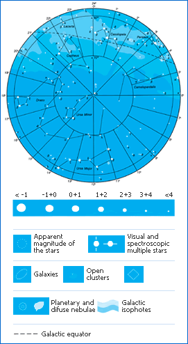
These maps
show the stars visible to the naked eye at intermediate
latitudes of the Northern hemisphere therefore in an area
of Central-Southern Europe.
The
round map represents the stars and constellations located
around the North celestial pole, that can be considered circumpolar
at the Northern intermediate latitudes.
The
other map shows the stars and the constellations that can
be seen during the year.
The map of the stars close to the South
celestial pole is not included, as these stars are never visible at
Northern intermediate latitudes.
Stars are traditionally grouped into
constellations, which are
areas of the sky which have been accurately defined by the
International Astronomical Union.
The main stars are defined using letters of the Greek alphabet,
but many of them are known by their traditional names.
For example
a Aquilae is called Altair, a Cygni is called Deneb..
The
position of the stars on the celestial sphere is defined by
using two coordinates, similar to longitude and latitude: they
are right ascension, measured in hours and declination, measured
in degrees.
The map also includes other objects such as nebulae, star
clusters and galaxies, as well as the Milky Way.
The line whose declination is equivalent to 0 is the celestial
equator. The undulated line is the ecliptic: this indicates the
position of the Sun between the stars during the year.
The planets and the Moon follow paths in the sky close to the
ecliptic. Venus, Mars, Jupiter and Saturn can be clearly seen
by the naked eye. Venus can be seen in the evening, after
sunset or in the morning before dawn.
The map also shows some of the lines that join the most important
stars of the constellations, which have no special astronomical
meaning but they make it easier to recognise the
various constellations, as they were indicated for centuries in
the star atlases.


 The motion of stars in the sky
 Learning about the sky
 Sky map


 The motion of stars in the sky
 Learning about the sky
 Sky map